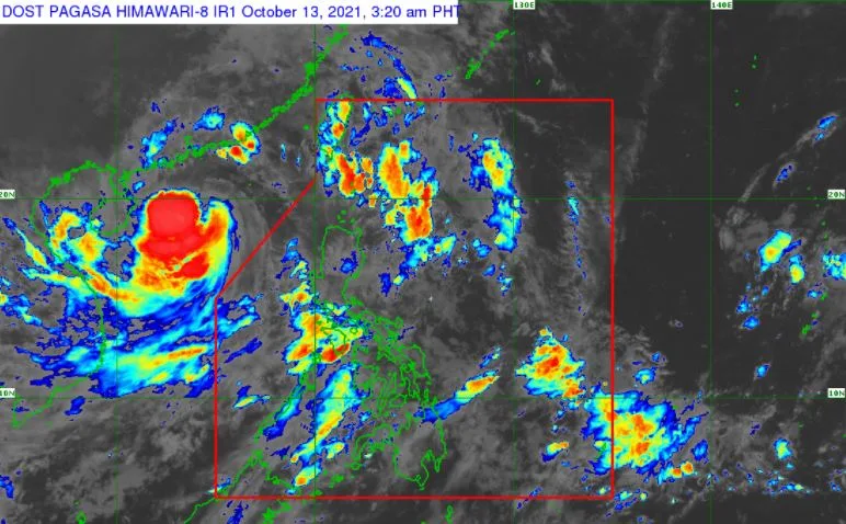
At 4:00 am today, the center of Severe Tropical Storm 'Maring' was estimated based on all available data over 765 km West of Calayan, Cagayan or outside the Philippine Area of Responsibility (PAR).
 |
| Satellite image of Bagyong 'Maring' as of 3:20 am, October 13, 2021. Photo from PAGASA |
'Bagyong Maring' has maximum sustained winds of 100 km/h near the center, gustiness of up to 125 km/h, and central pressure of 975 hPa. It is moving West northwestward at 30 km/h. Strong winds or higher extend outwards up to 800 km from the center.
TROPICAL CYCLONE WIND SIGNALS IN EFFECT
All Tropical Cyclone Wind Signals hoisted are now lifted.
TRACK AND INTENSITY OUTLOOK
The storm will continue moving westward over the West Philippine Sea and maintain its strength until it makes landfall in the vicinity of Hainan, China this afternoon or tonight.
HAZARDS AFFECTING LAND AREAS
Heavy Rainfall
Despite weakening trend of forecast rainfall over Northern Luzon in the next 24 hours, the high saturation of soil moisture in these areas due to large amounts of antecedent rainfall meant that flooding (including flash floods) and rain-induced landslides are still likely especially in areas that are highly or very highly susceptible to these hazard as identified in hazard maps even in the event of light to moderate rains.
Under the influence of the Southwest Monsoon enhanced by Severe Tropical Storm 'Maring', monsoon rains are possible over Bataan, Zambales, Occidental Mindoro, and Palawan within the next 24 hours.
Severe Winds
Owing to the consolidation in the wind field of 'Maring' and its continuous westward movement, prevailing winds over the country are now below warning criteria necessary for the hoisting of a Tropical Cyclone Wind Signal (TCWS).
As such, all wind signals in the country have been lifted. Nevertheless, gusty conditions reaching strong to gale-force in strength due to the enhanced Southwest Monsoon remain likely over MIMAROPA, Western Visayas, Bicol Region, and Extreme Northern Luzon, and possible over the rest of Luzon.
HAZARDS AFFECTING COASTAL WATERS
Under the influence of Severe Tropical Storm 'Maring' and the enhanced Southwest Monsoon, Gale Warning remains in effect for the northern and western seaboards of Luzon.
Moderate to rough seas (1.2 to 3.0 m) will prevail over the remaining seaboards of Luzon, and the western seaboards of Visayas and Mindanao. These conditions are risky for those using small seacrafts. Mariners are advised to take precautionary measures when venturing out to sea and, if possible, avoid navigating in these conditions.
Press Briefing: Severe Tropical Storm "#MaringPH" Tuesday, 5 AM October 13, 2021Press Briefing: Severe Tropical Storm "#MaringPH" Tuesday, 5 AM October 13, 2021 DOST-PAGASA Weather Specialist: Aldczar D. Aurelo
Posted by Dost_pagasa on Tuesday, October 12, 2021
'Maring', the 13th tropical cyclone this year, developed into a tropical depression while east of Bicol region on Thursday afternoon, October 7. This cyclone merged with the remnant low pressure area of 'Nando' on Sunday.
PAGASA predicts that 2–3 tropical cyclones may enter/develop in the Philippine Area of Responsibility (PAR) this month. On October 4, tropical depression 'Lannie' developed while east of Surigao del Norte and made 10 landfalls across northern Mindanao, the Visayas, and Palawan.
On average, there are 20 tropical cyclones that could form or enter the PAR each year. Only half of those are projected to make landfall.
The weather agency declared the onset of the rainy season on Friday, June 5.
— The Summit Express


