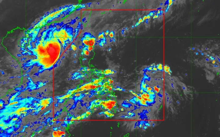
At 4:00 pm today, the center of 'Bagyong Quinta' was estimated based on all available data at 880 km East of Surigao City, Surigao del Norte.
SEE ALSO: 'Bagyong Quinta' PAGASA weather update October 25, 2020
'Quinta' has maximum sustained winds of 45 km/h near the center and gustiness of up to 55 km/h. It is moving westward slowly.
The new weather system will move generally northwestward today. On the forecast track, it will turn westward by Sunday (October 25) and will make landfall over Bicol Region by Monday (October 26).
After crossing Bicol Region, 'Quinta' will continue to track westward over the inland seas of Southern Luzon. It is likely to emerge over the West Philippine Sea by Tuesday.
Forecast Positions
Hazards affecting land
Rainfall: 'Bagyong Quinta' is not affecting the weather over any portion of the country at this time.
Winds: No tropical cyclone wind signal is currently in effect. However, occasional gusts due to the northeasterly surface windflow will be experienced over the Northern Luzon, especially in coastal and mountainous areas.
Hazards affecting coastal waters
Gale warning is in effect over the northern and western seaboards of Luzon due to rough to very rough seas (2.8 to 5.5 m). Sea travel is risky over these areas, especially for small seacrafts.
Moderate to rough seas (1.2 to 2.8 m) will prevail over the eastern seaboards of Luzon. Those with small seacrafts are advised to take precautionary measures when venturing out to sea.
— The Summit Express
The new weather system will move generally northwestward today. On the forecast track, it will turn westward by Sunday (October 25) and will make landfall over Bicol Region by Monday (October 26).
After crossing Bicol Region, 'Quinta' will continue to track westward over the inland seas of Southern Luzon. It is likely to emerge over the West Philippine Sea by Tuesday.
Forecast Positions
- 24 Hour (Tomorrow afternoon): 715 km East of Catarman, Northern Samar
- 48 Hour (Sunday afternoon):320 km East of Juban, Sorsogon
- 72 Hour (Monday afternoon): 70 km North of Romblon, Romblon
- 96 Hour (Tuesday afternoon):400 km West of Calapan City, Oriental Mindoro
- 120 Hour (Wednesday afternoon):700 km West of Subic, Zambales (OUTSIDE PAR)
Hazards affecting land
Rainfall: 'Bagyong Quinta' is not affecting the weather over any portion of the country at this time.
Winds: No tropical cyclone wind signal is currently in effect. However, occasional gusts due to the northeasterly surface windflow will be experienced over the Northern Luzon, especially in coastal and mountainous areas.
Hazards affecting coastal waters
Gale warning is in effect over the northern and western seaboards of Luzon due to rough to very rough seas (2.8 to 5.5 m). Sea travel is risky over these areas, especially for small seacrafts.
Moderate to rough seas (1.2 to 2.8 m) will prevail over the eastern seaboards of Luzon. Those with small seacrafts are advised to take precautionary measures when venturing out to sea.
— The Summit Express


