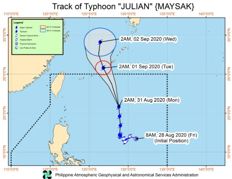
MANILA, Philippines –'Bagyong Julian' (international name: Maysak) accelerates towards the north northwest while maintaining its strength and far from the Philippine landmass, state weather bureau PAGASA announced in its 11:00 am bulletin on Monday, August 31, 2020.
At 10:00 am today, the eye of 'Bagyong Julian' was located based on all available data at 710 km East Northeast of Basco, Batanes.
Typhoon 'Julian' has maximum sustained winds of 150 km/h near the center and gustiness of up to 185 km/h. It is moving north northwestward at 30 km/h.
'Julian' is forecast to exit the Philippine Area of Responsibility (PAR) and pass between the Miyako and Okinawa Islands in the Ryukyu archipelago (southern Japan) tonight or tomorrow early morning.
PAGASA said 'Julian' may reach its peak intensity between tonight and tomorrow morning.
Forecast position
Hazards affecting land
The raising of Tropical Cyclone Wind Signal is unlikely throughout the forecast period.
Today, the Southwest Monsoon may bring light to moderate with at times heavy rains over the northern portion of Palawan including Calamian and Cuyo Islands, Batanes, and Babuyan Islands.
The public and disaster risk reduction and management offices concerned are advised to monitor the Thunderstorm/Rainfall Advisories and Heavy Rainfall Warnings issued by PAGASA Regional Services Divisions and take appropriate measures.
Hazards affecting coastal waters
Gale Warning remains in effect for the seaboards of Batanes and Babuyan Islands. Sea travel is risky due to rough to very rough seas over these areas (2.8 to 4.5 m).
Moderate to rough seas (1.2 to 3.4 m) will be experienced over the seaboards of the rest of Luzon and Visayas due to the Southwest Monsoon and Typhoon Julian.
Those with small seacrafts are advised to take precautionary measures while venturing out to sea.
'Julian' is the country's 10th tropical cyclone for 2020 and 6th for August alone after Tropical Storms Enteng (Jangmi) and Igme (Bavi) and tropical depressions Ferdie, Gener, and Helen.
On average, there are 20 tropical cyclones that could form or enter the PAR each year. Only have of those are projected to make landfall.
PAGASA declared the onset of rainy season on June 12.
— The Summit Express
At 10:00 am today, the eye of 'Bagyong Julian' was located based on all available data at 710 km East Northeast of Basco, Batanes.
Typhoon 'Julian' has maximum sustained winds of 150 km/h near the center and gustiness of up to 185 km/h. It is moving north northwestward at 30 km/h.
'Julian' is forecast to exit the Philippine Area of Responsibility (PAR) and pass between the Miyako and Okinawa Islands in the Ryukyu archipelago (southern Japan) tonight or tomorrow early morning.
PAGASA said 'Julian' may reach its peak intensity between tonight and tomorrow morning.
Forecast position
- 24 Hour(Tomorrow morning): 830 km North Northeast of Extreme Northern Luzon (OUTSIDE PAR)
- 48 Hour(Wednesday morning):1,145 km North Northeast of Extreme Northern Luzon (OUTSIDE PAR)
Hazards affecting land
The raising of Tropical Cyclone Wind Signal is unlikely throughout the forecast period.
Today, the Southwest Monsoon may bring light to moderate with at times heavy rains over the northern portion of Palawan including Calamian and Cuyo Islands, Batanes, and Babuyan Islands.
The public and disaster risk reduction and management offices concerned are advised to monitor the Thunderstorm/Rainfall Advisories and Heavy Rainfall Warnings issued by PAGASA Regional Services Divisions and take appropriate measures.
Hazards affecting coastal waters
Gale Warning remains in effect for the seaboards of Batanes and Babuyan Islands. Sea travel is risky due to rough to very rough seas over these areas (2.8 to 4.5 m).
Moderate to rough seas (1.2 to 3.4 m) will be experienced over the seaboards of the rest of Luzon and Visayas due to the Southwest Monsoon and Typhoon Julian.
Those with small seacrafts are advised to take precautionary measures while venturing out to sea.
'Julian' is the country's 10th tropical cyclone for 2020 and 6th for August alone after Tropical Storms Enteng (Jangmi) and Igme (Bavi) and tropical depressions Ferdie, Gener, and Helen.
On average, there are 20 tropical cyclones that could form or enter the PAR each year. Only have of those are projected to make landfall.
PAGASA declared the onset of rainy season on June 12.
— The Summit Express


