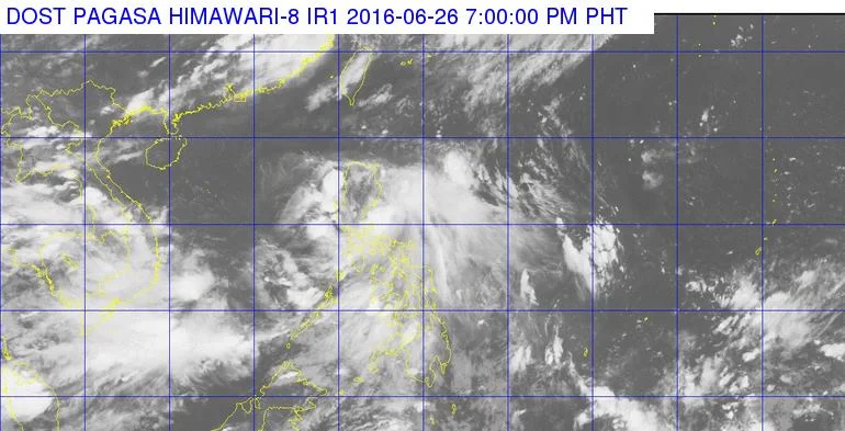
MANILA, Philippines - Tropical depression 'Ambo', the first cyclone to enter the Philippine Area of Responsibility (PAR) this 2016 has maintained its strength and now heading towards Aurora province, state weather bureau PAGASA announced on Sunday night, June 26.
At 7:00 p.m. today, the center of 'Bagyong Ambo' was estimated based on all available data at 120 km North of Daet, Camarines Norte (15.1°N, 123.4°E).
It has maximum winds of 45 kph near the center and forecast to move West Northwest at 22 kph.
Tropical Cyclone Warning Signal (TCWS) No. 1 (30-60 kph is expected in at least 36 hrs) in the following areas of Luzon: Catanduanes, Camarines Norte, Northern Quezon including Polillo Islands, Aurora and Quirino.
Impacts of the wind:
Forecast Positions:
The estimated rainfall amount is from 2.5 – 10 mm per hour (moderate-heavy) within the 200 km diameter of the Tropical Depression.
Likewise, occasional moderate to heavy rains is expected over Northern and Central Luzon, CALABARZON and Bicol Region.
'Ambo' is expected to weaken after making landfall over Aurora province early morning tomorrow, June 27.
Residents in low lying and mountainous areas of the provinces with TCWS#1 are alerted against possible flashfloods and landslides.
At 7:00 p.m. today, the center of 'Bagyong Ambo' was estimated based on all available data at 120 km North of Daet, Camarines Norte (15.1°N, 123.4°E).
It has maximum winds of 45 kph near the center and forecast to move West Northwest at 22 kph.
Tropical Cyclone Warning Signal (TCWS) No. 1 (30-60 kph is expected in at least 36 hrs) in the following areas of Luzon: Catanduanes, Camarines Norte, Northern Quezon including Polillo Islands, Aurora and Quirino.
Impacts of the wind:
- Twigs and branches of trees maybe broken
- Some banana plants may tilt or land flat on the ground
- Rice in flowering stage may suffer significant damage
- Some nipa and cogon houses maybe partially unroofed
- Sea travel of small sea crafts and fishing boats is risky
Forecast Positions:
- 24 hour (Tomorrow evening): 190 km Northwest of Dagupan City
- 48 hour (Tuesday afternoon): 760 km West of Laoag City
The estimated rainfall amount is from 2.5 – 10 mm per hour (moderate-heavy) within the 200 km diameter of the Tropical Depression.
Likewise, occasional moderate to heavy rains is expected over Northern and Central Luzon, CALABARZON and Bicol Region.
'Ambo' is expected to weaken after making landfall over Aurora province early morning tomorrow, June 27.
Residents in low lying and mountainous areas of the provinces with TCWS#1 are alerted against possible flashfloods and landslides.


