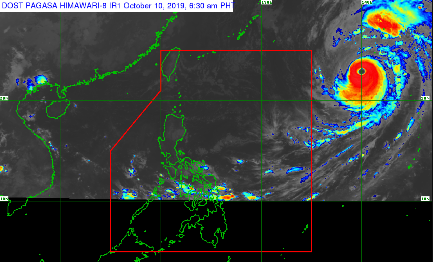
MANILA, Philippines – Super Typhoon 'Hagibis' (international name) still has a low chance of entering the Philippine Area of Responsibility (PAR), state weather bureau PAGASA said Thursday morning, October 10, 2019.
UPDATE: #PrayForJapan: Super Typhoon Hagibis could match 1958 Ida that killed 1,200 in Japan
As of 4 a.m., the weather disturbance was located 1,845 kilometers east of Basco, Batanes packing maximum winds of 200 kph and gusts of up to 245 kph. It is moving northwest at 20 kph.
The trough of 'Bagyong Hagibis' is currently affecting Bicol Region, eastern Visayas and eastern Mindanao bringing light to moderate rains. Gale warning was up over these areas.
Metro Manila, rest of Luzon and other parts of the country will have good weather today.
The weather central advised to keep monitoring for the updates on 'monster' typhoon Hagibis.
— The Summit Express
UPDATE: #PrayForJapan: Super Typhoon Hagibis could match 1958 Ida that killed 1,200 in Japan
 |
| Satellite image of Typhoon Hagibis as of 6:30 am, October 10 | Courtesy of DOST-PAGASA |
"Mas bumaba pa ang chance na pumasok ito sa ating PAR at unti-unti 'tong pumapa-hilaga towards Japan," said DOST-PAGASA weather specialist LorieDin Dela Cruz.
As of 4 a.m., the weather disturbance was located 1,845 kilometers east of Basco, Batanes packing maximum winds of 200 kph and gusts of up to 245 kph. It is moving northwest at 20 kph.
"Nasa upper limit po ito ng Typhoon Category so napakalakas po nito at mapaminsala," Dela Cruz added.
The trough of 'Bagyong Hagibis' is currently affecting Bicol Region, eastern Visayas and eastern Mindanao bringing light to moderate rains. Gale warning was up over these areas.
Metro Manila, rest of Luzon and other parts of the country will have good weather today.
The weather central advised to keep monitoring for the updates on 'monster' typhoon Hagibis.
— The Summit Express

